| Catalogue number: 0101-041 (Smithsonian Institution, Global Volcanism Program) Height above sea level: 421 m Location: 38.63°N, 15.07°E Total area: 3.4 square kilometres (island of Panarea) |
|
|
Panarea is the smallest of the Aeolian Islands, but contra among the archipelago’s potentially active volcanoes. Considered until recently an ‘extinct’ volcano, there is now data indicating a much younger volcanism, possibly of Holocene age. Furthermore, there is an area of active submarine fumaroles in the area of the islets and rocks east of Panarea, which was already known in Greco-Roman times and was the site of a spectacular increase in gaseous emissions in the autumn of 2002.
Panarea is part of a large, mostly submerged volcanic apparatus, of which the emerged portion, including the Dattilo, Basiluzzo, Lisca Bianca and Lisca Nera rocks, represents only the rim of an elliptical volcano-tectonic depression with a major axis oriented E-W. This volcanic structure extends for a total of 460 km2, rising from a depth of about 1000 m; the emerged portion, deeply affected by the modelling processes operated by surface erosion and tectonics, is very rugged on the western and northern slopes due to the presence of steep cliffs, while on the southern and eastern slopes it is possible to note the presence of three marine terraces testifying to both the erosive action operated by the sea and the relative uplift that occurred in successive stages.
Geological evolution of Panarea
Panarea (3.3 km2) is part of a large, mostly submerged volcanic apparatus, of which the emerged portion, including the Dattilo, Basiluzzo, Lisca Bianca and Lisca Nera rocks, represents only the rim of an elliptical volcano-tectonic depression with its major axis oriented E-W. This volcanic structure extends for a total of 460 km2, rising from a depth of approximately 1000 m; the emerged portion, deeply affected by the modelling processes operated by surface erosion and tectonics, is very rugged in the western and northern slopes due to the presence of steep cliffs, while in the southern and eastern ones it is possible to note the presence of three marine terraces testifying to both the erosive action operated by the sea and the relative uplift that occurred in successive stages.
The oldest lavas outcrop in the south-western sector of the island and were erupted about 150 ka ago (Calanchi et al., 1999). Volcanic activity is still present today in the form of fumarolic activity, which is intensely widespread at a depth of about 20 m, between the islands of Bottaro, Dattilo, Lisca Nera, Lisca Bianca and Panarelli, and on the surface at Calcara.
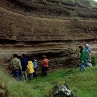
The geological structure of the Panarea area is the result of a rather complex volcanic activity characterised by effusive and explosive events, with pyroclastic coverings in place, emanating from centres, also external to the island, aligned along a NE-SW orientation.
Period I – The products of this phase, defined as Paleo-Panarea (Rossi et al., 1987) include all the pyroclastites, lavas, domes and dykes associated with the activity of multiple effusive centres (Ditella, P.ta Muzza, P.ta Scritta, Palisi) located, approximately, in the western and northern sectors of the island.
Period II – An important angular discontinuity separates the products of Paleo-Panarea, levelled by marine erosion, from those of the Cala Bianca synthema, dated 132 ka. In this phase, activity moved to the western sector of the island, with the emission of andesitic lava flows and the formation of domes, locally overlain by a pyroclastic formation consisting of breccias and lapilli.
Period III – A new episode of marine erosion separated the products of the Caletta dei Zimmari synthema, active between 132 and 127 ka. During this period, several highly viscous lava flows were emitted from several points aligned in the NNE-SSO and NO-SE directions. The domes in the centre of the Pit also belong to this phase.
Period IV – At the end of the activity in the Caletta dei Zimmari, a lull in volcanic activity in that part of the island took place, but localised eruptions occurred to the east, causing the centres of Panarelli, Dattilo, Le Formiche, Bottaro, Lisca Bianca and Lisca Nera to be built around 130 ka (Gabbianelli et al., 1990). The products consist of massive viscous lavas, now often altered, issued from small monogenic centres. Period V – During this cycle, numerous powerful lava flows outcropping mainly in the central-western sector of Panarea (Punta del Corvo), and a sequence of lavas and pyroclastites, present along the eastern coast of Panarea. Period VI – At the end of the activity of the Punta del Corvo centre, approximately 124 ka ago, after an important lull in eruptive activity that lasted up to approximately 59 ka and allowed marine erosion to extensively process the volcanites already in place, the predominantly explosive activity of Grotta delle Palombe and the mixed activity of the Basiluzzo centre and Punta Torrione began. At the end of this magmatic cycle, intense tectonic activity disrupted the island’s morphology (Lanzafame and Rossi, 1984); the entire central sector was lowered to a depth of 100 m, with movements that are presumably still in progress, since archaeological evidence of ancient Roman baths has been found at the submarine fumaroles between the Dattilo, Lisca Bianca, Lisca Nera and Panarelli rocks. |
|
© 2025 Le Isole Eolie. All rights reserved.
WordPress Responsive Theme designed by Theme Junkie


