Stromboli Island (STRONGYLE) Surface area 12.6 kmq. Inhabitants 550
| Catalog number: 0101-04= Elevation above sea level: 924 m Location: 38.789°N, 15.213°E Total area: 12.6 square kilometers (Stromboli Island) |
|
|
Stromboli, one of the few volcanoes on Earth in almost continuous activity, is the northernmost of the seven Aeolian Islands. Its edifice rises more than 920 meters above sea level, but its base is at a depth of about 2000 meters below sea level. Contrary to what it may seem when you see Stromboli from a distance, this volcano is very complex, reflecting its history, which is characterized by the growth and subsequent destruction of a series of volcanic edifices. The life of each of these edifices seems to end with a sector collapse, that is, a massive rock slide, which leaves a huge collapse niche (or amphitheater). After the most recent collapse, about 5000 years ago, a new edifice began to build itself inside the last collapse niche, which is known as “present-day Stromboli”, whose active side constitutes the Sciara del Fuoco. The summit craters of this edifice are located at an altitude of about 750 m, that is, more than 100 meters below the highest point of the volcano. Immediately above the crater area (also known as the “crater terrace”) stands Pizzo sopra la Fossa, a destination for many visitors that allows a spectacular view into the craters. For several decades, three main active craters have been distinguishable, one in the north-east end of the crater area, one in the center, and the third in the south-west part. Each of these craters contains several eruptive vents, the number (and size) of which varies depending on the levels of eruptive activity. In periods of more intense activity, the number of active vents can be up to 10. Active craters are the site of persistent activity, ongoing for several centuries, which normally consists of small explosions well separated from each other, with the launching of fragments of incandescent lava and variable quantities of ash up to a few dozen or hundreds of meters above the vents. The explosions usually last a few seconds or tens of seconds, and are well separated from each other, with intervals that can vary from a minute to several hours. This activity is called “Strombolian”. During periods of more pronounced activity, some vents produce an almost continuous lava ejection activity (“spattering”), which can rarely lead to the formation of small intra-crater lava flows, as at the end of August 2009 and on 7 January 2010. Eruptions with emission of lava flows (overflows from the craters or opening of new effusive vents outside the craters) occur at irregular intervals (on average once or twice per decade) and lead to the temporary cessation of persistent Strombolian activity at the summit craters. The flows can reach the sea, where lava deltas form that are usually rapidly eroded by the action of the sea. Such effusions can last from a few days to many months (eruption 2002-2003: 206 days). The beginning of a lava effusion is often accompanied by strong explosive activity at the summit craters. The most dangerous phenomenon in Stromboli’s activity are explosions larger than usual Strombolian activity, called “paroxysms”. Many of these events launch bombs and blocks of plurimetric dimensions into the summit area (Pizzo sopra la Fossa). During the strongest paroxysms, the fallout of incandescent pyroclastic material can cause fires in the vegetation on the outer slopes of the volcano. The strongest paroxysms in the last 100 years were those of 1919, 1930, and 2003. Geological evolution of Stromboli Stromboli has a surface area of 12.2 km2, rises up to 924 m above sea level in Vancori, starting from the metamorphic basement located at a depth of about 2000 m. Its morphology, also remembered by the ancient Greek name “Strongyle” which means round, is very simple, constituting the product of the succession of various volcanic cycles of the same central building. Stromboli, in reality, has a slightly elongated shape in a NE direction, towards the islet of Strombolicchio, an eccentric neck located about two km from the main island (Rosi, 1980). On the northern side there is a collapse structure called Sciara del Fuoco recognizable up to a depth of about 1700 m below sea level (Romagnoli et al. 1993). This structure collects the pyroclastic and lava materials erupted from the summit craters. The oldest visible activity (about 200 ka) is found at Strombolicchio (Gillot and Keller, 1993), while that of Stromboli is younger by about 100,000 years. The current activity is linked to three vents located on a terrace at an altitude of 750 m a.s.l. to the NW of Pizzo sopra la Fossa. The typical activity is Strombolian, with rare lava effusions and sporadic pyroclastic flows, lahars and burning clouds (Barberi et al. 1993). The geology of the island has been the subject of numerous studies aimed at the space-time reconstruction of volcanic events (Rosi, 1980, Francalanci et al. 1986, Francalanci et al. 1989, Hornig-Kjarsgaard et al. 1993, Gillot and Keller, 1993, Keller et al. 1993 and Pasquare et al. 1993). Various authors agree in dividing the activity of the island into five main periods: Strombolicchio, Paleostromboli, Vancori, Neostromboli and Recent Stromboli. Period I – It is represented by the volcanics of the 49 m high neck of Strombolicchio, dated 204 ka (Gillot and Keller, 1993) and consisting of dykes, breccias and lavas. Period II – It includes the oldest products of the island of Stromboli (Paleostromboli I) that formed a stratocone about 400 m high; its activity began about 85 ka ago in the southern sector of the island, with the emission of lava flows and pyroclastic fallout, phreatomagmatic and lahars. The cycle was closed by a caldera collapse (64 ka). Period III – Paleostromboli II began its activity in the same area as Paleostromboli I, about 64 ka (K/Ar dating Gillot and Keller, 1993) filling the caldera formed at the end of Paleostromboli I, with the basic lavas and scoriae of the Rina Inferiore unit (Hornig-Kjarsgaard et al. 1993) and with the subsequent lavas and scoriae of the Omo where it is easy to find magmatic and quartz xenoliths. Period IV – Paleostromboli III resumes the markedly more explosive characteristics of Paleostromboli I, with the emission (about 35 ka) of the pyroclastics of the Vallone di Rina and those of Malo Passo and then of lava flows (Hornig, 1984). The sequence ended with the emplacement of the Cavoni Pyroclastics and the explosive breccias of the Malo Passo centre. Period V – In the north-eastern sector of the island, in angular discordance with the products of Paleostromboli I and II, the Scari pyroclastics were emplaced (Hornig-Kjarsgaard et al. 1993), a pyroclastic complex with intercalated small lava flows, attributable to a centre external to the larger Paleostromboli. The presence within the Scari series of the regional marker called ” Ischia Layer”, an ochre cinerite probably linked to the eruption of the Green Tuff of Mount Epomeo on the island of Ischia (Morche, 1988), makes it appear contemporary (35 ka ago). The stratigraphic sequence is closed by phreatomagmatic deposits resting on lapillous layers. Period VI – At the end of the activity of Paleostromboli III, a large summit caldera occupied the crater area (Rosi, 1980). About 26 ka ago, the basic lavas of the center of Vancori began to flow inside the depression, partially filling it, due to the persistence of subsidence processes. The last lavas emitted covered the entire summit area and today emerge near Vancori and Frontone; and, they constitute the summit of the current volcano (924 m a.s.l.). A new volcano-tectonic event subsequently affected the edifice, triggering a collapse of the entire western and northern portion of the volcano, accompanied by the emission of the Frontone breccia. Period VII – Slightly below the summit of Vancori, the Neostromboli cone formed, about 13 ka ago. The activity of this center produced lava effusions on the entire western flank (Vallonazzo, Timpone del Fuoco, Nel Cannestrà, Punta Labronzo).
|
|
- Comunicati giornalieri
- Webcam Stromboli
- Escursioni
- Per ulteriori informazioni:
- SPECIALE STROMBOLI A 360°
- Itinerari riserva naturale di Stromboli
- Previsioni del mare Stromboli
- Stromboli Progetto Esemar
- Galleria fotografica Stromboli
The flora of Stromboli includes an important endemic species of the Aeolian Islands, the Cytisus Aeolicus, a small tree of the Leguminosae family, which once formed thickets along the slopes of the island. Today this species survives in the Schicciole area, and for its protection a project (“Eolife 99”) co-financed by the EU has been launched, which also concerns another interesting endemic species, the Chenopodiacea Bassia Saxicola, present on the islet of Strombolicchio.Historical notes
The most distant and easternmost of the Aeolian Islands, Stromboli is about 22 miles from Lipari. The island is a volcano that emerges from the sea; the emerged part, in persistent activity for at least 2000 years, was formed mainly during two cycles of activity. An ancient cycle, consisting of eruptions of solid material and lava flows, which formed the entire eastern part of the island; a more recent cycle, consisting of lava flows, which formed the entire western half of the island. The current activity is considered to be part of the recent cycle. The crater area is formed by three active cones, whose volcanic activity is predominantly explosive. Stromboli is the only volcano in Europe and one of the few in the world with permanent eruptive activity. This is why the island has been called, since classical antiquity, the “lighthouse of the Tyrrhenian Sea”. Stromboli was inhabited until the Bronze Age. In 1975, a Greek necropolis was discovered with tombs from the end of the 4th and the first decades of the 3rd century BC. The economic activity was based on agriculture and its port was a stopover for merchant ships crossing the Tyrrhenian Sea. The population decline of the island occurred in 1930, when a very strong eruption and a frightening tsunami convinced many islanders to emigrate. In the 1950s, tourism began to develop and many of the Aeolian-style houses, abandoned at the time of the 1930 eruption, once renovated became holiday destinations.
General information
It is the northernmost of the islands and has a population of about 400 inhabitants. The island, to the north of which the very steep rock of Strombolicchio rises, is made up of a volcanic edifice, which reaches 926 m, and has various eruptive vents, perpetually active, with spectacular eruptions of lapilli and incandescent materials, which fall along the steep wall called Sciara del Fuoco. The volcanic apparatus constitutes a so-called strato-volcano or mixed volcano, in which rocks derived from lava flows alternate with layers of pyroclastic materials. It extends under the sea for about a thousand meters: in fact, the first eruptive manifestations, dating back to the Cenozoic or Tertiary era, were underwater. The coasts are high and steep, with few beaches. The population lives in the centers of Ginostra and Stromboli, and the traditional economic activities are fishing, viticulture and caper picking, as well as, increasingly, tourism. Archaeological excavations have brought to light the remains of a Greek necropolis.
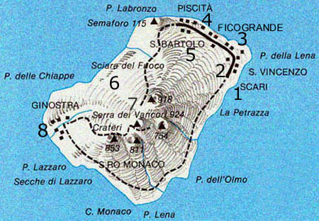
Excursions by Land Starting from the pier of Scari, you can dedicate yourself to an initial exploration of the streets and alleys of S. Bartolo, patron saint of the island. In front of the Ficogrande landing stage, about a mile from the coast, the majestic islet of Strombolicchio (in the shape of a medieval castle) rises. What appears is the remains of a small cone of a lateral eruption.
Trekking Of naturalistic interest is the climb to the crater. Three hours of walking to reach the high altitude, thus being able to witness the explosions from nearby areas. It is advisable to take the excursion with authorized guides.
Excursions by sea Starting from Scari, reaching the body of water in front of Punta Labronzo you can admire the “Sciara del Fuoco”: picturesque explosion of lapilli and incandescent lava flows. Continuing you reach the small village of Ginostra, an uncontaminated paradise, between the green of the Mediterranean scrub and the blue of the sea.
The Sciara del Fuoco A wall of rock, which sinks into the deepest abysses, to seabeds inaccessible to divers, heading towards the opposite Fossa del Tirreno (over three thousand meters deep).
The Dorsale della Sciara This is an imposing ridge with two peaks: the first at 35 meters, the second at 20. Once you reach 35 meters, a precipice opens up, which is lost in a black abyss. On the rocks of the bottom you can discover a large quantity of pentagon stars.
The Secca di Scirocco It is an imposing mountain surrounded by a quantity of large boulders rich in fish and spectacular morphologies, all its slopes are covered with red gorgonians.
- DA VISITARE:
- Osservatorio Vulcanologico, Chiesa di San Vincenzo
- ESCURSIONI:
- Al Cratere (obbligo di guida autorizzata). Ginostra, pittoresca e solitaria frazione di Stromboli, raggiungibile per gli amanti del trekking in quattro ore e mezzo di marcia
- DA NON PERDERE:
- Giro dell’isola con sosta: Forgia Vecchia (antica sciara); Punta dell’Olmo; Punta Lena (villaggio disabitato); Punta Lazzaro o Pertuso (Ginostra); Sciara del fuoco; Piscità e Ficogrande, elegante baia di fronte a Strombolicchio (isolotto alto 43 m. sormontato dal faro)
- NOTIZIE UTILI:
- Guardia medica: Via Vittorio Emanuele 090.986097
- Collegio Regionale Guide Alpine e vulcanologiche 095.7914755
- Snav 090.986003
- Siremar 090.986016

- LEGENDA: 1-Scari 2-San Vincenzo 3-Ficogrande 4-Piscità 5-San Bartolo 6-Sciara del Fuoco 7-Vancori (sopra i crateri del vulcano) 8-Ginostra


